A river adventure: Explore from source to sea
- 6 hours ago
- 4 min read
Hey there, travelers! It’s Willy, Will County’s wandering woodchuck and nature guide.
In our preserves I see creeks, ponds, lakes, rivers and all the plants and animals that call those wetlands home. Today, we’re going on a journey to explore the winding wonders that we call rivers.
At the beginning

For the first part of our journey, you’re going to need hiking shoes.
A river is flowing water that travels across or through land, but even the mightiest of rivers start small. This start, also known as the source, is located at higher elevation such as a mountain. Do you hear that trickling sound? Sources can start from rainfall, melting snow or from an underground spring.
We are in Wisconsin and just found the source of the Des Plaines River. Let's follow it.
Did you notice? We passed by two streams that flow down into the Des Plaines. The river is getting bigger!

Like a kid on a sugar rush, young rivers seem to be full of energy. Hop in my canoe — we need to see where this goes! Young rivers flow fast and strong, picking up rocks and soil as they flow and grow.
Uh oh … are those rapids ahead?
In the middle
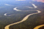
Phew, we made it! We are still making great time, but the current is slowing down as the maturing river gets wider and deeper.
Did you bring a fishing pole? No? Guess we’ll just watch the experts then. That statue-like egret near the shore is about to grab his lunch out of the water.
Look ahead! We are coming to a fork in the river. No, put that away; we’re not eating yet. I guess all that rock, sand and soil that the fast-moving waters brought down became an island in the middle of the river.
Should we paddle around the island? Wait! I recognize it — it’s an island of hiding places. No, really! All sorts of humans would dig caches and hide their food and other trinkets here. That’s how it got its name: Isle a la Cache.
Many years ago, fur traders from Canada and Indigenous people would travel on this very river to meet and trade. A river as a highway. Funny to think of it now with all the roads! Let’s stop and visit. Maybe we’ll see some Blanding’s turtles basking.
Words to know
Cache: A secure hiding place especially for concealing and preserving provisions.
Mouth: A place where the river meets the sea.
Rapids: A part of a river where the current is fast and the surface is usually broken by obstructions.
Source: The beginning of a river.
Tributary: A smaller stream, creek, brook or river that flows into a larger river.
Grab your paddle. We have much more to see as we head south. Look! Even though we are in the middle of the river, smaller rivers and creeks are still joining us. That’s the DuPage River there. That must mean we are getting close to a very important spot in Will County, the river confluence.

Near Four Rivers Environmental Educational Center, you can see where these two rivers (the DuPage and Des Plaines) are joined by another, the Kankakee River, to flow into an even larger river, the Illinois.
Did you pack your camping gear, traveler? Our river journey is going to take us across the state.
As we leave Will County and paddle down the Illinois River, we will see small cities, small towns, barges and plenty of wildlife. Did you see that shadow pass over the sun? That high-pitched ki-ki-ki-ki call tells us it’s a bald eagle!
Keep paddling, friend. The funny thing about rivers is sometimes there is no “end.” No matter how big you think a river is, it might feed into an even bigger one. While we are coming close to the “end” of the Illinois River, our trip is not over. This river flows into one of the biggest rivers in the world: the Mississippi River.
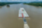
We’re going to need a bigger boat for this part of the journey. Plenty of humans today still use this as a highway — barges for transporting goods, steamboats for tourists and small boats for recreation sailing around this enormous river. Too many waves for our human- and woodchuck-propelled canoe!
The mouth
We have a lot of traveling left, so let me tell you what’s ahead so you’re prepared. The Illinois River joins the Mississippi River in the middle.
As we wind south past the states of Illinois, Missouri, Kentucky, Tennessee, Arkansas and Mississippi, we will see some of the same wildlife we have in Will County, such as great egrets, and some similar but different species, such as the alligator snapping turtle, and some completely new species. (Pro tip: Keep your fingers inside the boat — there’s alligators living in this part of the river!)
The last state the river flows through is Louisiana. By the time we get there, people will call this an “old river” because it moves even slower. The mouth, or end, of the Mississippi River (and our journey) is here because this river flows right into the Gulf of Mexico.
Now that we know what’s ahead, let’s enjoy the rest of our journey and go with the flow.